
Just the phrase, “sleeping under the stars” evokes an image of childhood for me. I was a Boy Scout in Oregon and then Alaska as my father moved from one job to another. As a kid, I first saw the Milky Way from the Pacific Crest Trail near Mount Hood in Oregon and still remember what it was like seeing a sky splashed full of stars reflected in the lake beside which we camped. It was our universe: an infinite expanse even greater than the distant ridgeline of trees or the more distant mountains of the Cascades to north and south. I felt I could get lost in that starry sky and who knows what wonders there might be out there among those stars? In Alaska, I fell in love with the aurora borealis during the long dark winter months and still remember what it was like to have them light up the snow around me on the frozen lake where our troop had set up our tents. No wonder I eventually became an astronomer.
But even as I gained access to some of the world’s largest telescopes and wrote papers on dark matter and pulsating stars, I never forgot where my love of the sky started. I once spent a year traveling the country working with National Park Service rangers and writing a book on all the ways visitors could experience astronomy in the parks. I led tours to see the aurora in Alaska and have trained river rafting guides in the Grand Canyon how to answer the question, “what star is that?” and “why are there so many more stars here than at home?” Because those visions of stars, the Milky Way, and even the northern lights, are becoming harder to see every year.

I’m an astronomer, but I’ve also traveled all over the world to observe the sky both professionally and as a tourist (and now tour leader). I’ve seen the heart of our galaxy from the Outback in Australia and high in the Chilean Andes after a solar eclipse. I once stargazed my way across the Atlantic on a four-masted sailing ship and I’ve seen a star-filled sky while hiking the Continental Divide. I care about the darkness because I know what I am missing due to light pollution. But why should anyone else?

In general, Maine and the northern New England states are the best places along the Trail to enjoy dark night skies. In Maine, the area surrounding Rangeley — a community that is the gateway to the Bigelow Mountain Range — is a great spot to view night skies as well as along the A.T. in the Green Mountain National Forest in New Hampshire. Areas in the south around Mount Rogers in Virginia and Clingmans Dome in the Smokies in North Carolina and Tennessee are also some of the better places for experiencing dark night skies. These areas are farthest from high density populations and have the added benefit of elevation. Some states have “dark sky” designated parks, communities, or areas. The International Dark Sky Places conservation program recognizes excellent stewardship of the night sky. Designations are based on stringent outdoor lighting standards and innovative community outreach.
Other Notable Dark night sky viewing along the a.t.
/ Chestnut Ridge looking down onto Burkes Garden near Bland and Burkes Garden, Virginia
/ Nantahala National Forest near Franklin, North Carolina (e.g. Wesser Bald)
/ Little Hump Mountain and Big Hump Mountain in North Carolina
/ Doll Flats in Tennessee
/ Chattahoochee National Forest — Gooch Gap and Hickory Flats in Georgia
Astronomers are not the only species that depend on darkness to thrive. Take fireflies for instance. I’d never seen a firefly before moving to the East Coast. Even today after 25 years I think they are still an utterly magical sight blinking and flashing in a wooded darkness. Recent research shows female fireflies exposed to increasing ambient light do not flash back to males as much as those under natural darkness and thus decrease their chances of finding a mate. How much would we lose to live in a world without fireflies?
Birds navigate by the stars. Their seasonal migrations spanning multiple continents put even the most avid A.T. thru-hiker to shame. Yet the constellation of city lights that grows ever brighter — and increasingly blue-white like the stars overhead thanks to the advent of LED streetlights — appears to throw that navigation into disarray. Who among us could imagine any place claiming to be “wild” that didn’t have birds?

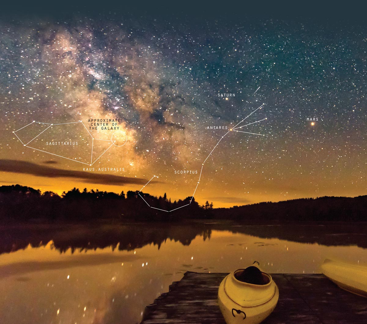
One way to gauge how much light has affected your view of the sky and how non-pristine your sky may be, is by consulting the Bortle Scale. A Bortle class of 9 is an inner-city sky so bright that only a handful of the brightest stars are visible, none making up even a full constellation beyond maybe the Big Dipper. Under a Bortle class 9 night, the Milky Way is completely invisible and city lights illuminate the clouds overhead and your eyes never fully adapt to the darkness. At the other end is a Bortle class 1 sky that is utterly pristine, with no light domes even faintly visible on the horizon and a sky so dark that clouds (and even your hand in front of your face) are just a dark hole on the sky. The Milky Way from these locations is visible all the way to the horizon and looks so bright that the dark clouds of interstellar gas and dust that span the light years throughout our galaxy, render the Milky Way overhead richly veined as if it was carved from celestial marble.
Believe it or not, while the sky above nearly every major population center is classified on a Bortle Class 8 or 9, there are literally fewer than a dozen regions in the continental U.S. that are still Bortle class 1. While most of these pristine skies are in the Western U.S. along the Continental Divide and Pacific Crest Trails, one is in the East and it is in the area around Katahdin at the northern end of the Appalachian Trail in Maine. There are many maps you can find online that will show you light pollution and Bortle scale maps for the country, and I’ve even published a small field guide that shows you the Milky Way at different times of year and how to estimate the Bortle brightness for wherever you happen to be. Think about that the next time you go out for a hike or just outside your front door at night. Think how much the lights of our civilization have already altered our wild places, even areas hundreds of miles away from major cities.

I once had a lighting engineer take issue with my desire to see the stars. He asked me, “isn’t that what the Hubble Space Telescope is for?” A year later, I was in Bryce Canyon National Park talking to one of the NASA astronauts who worked on Hubble about what he thought of that question. He looked out over the hoodoos and buttes to the distant horizon and wryly said, “Why do we need national parks? Isn’t that what pictures on the internet are for?” Our parks, our forests, and our trails are the single best ways we can touch, breathe, hear and see the natural world on which we live. As our ideas of conservation have expanded to include not just the rock at our feet, but the water that flows through it, the plants and wildlife that make it their home, and the clear air that allows us to breathe and enjoy it, the night sky above is the latest addition. We wouldn’t settle for a world made invisible by smog, so why should we accept the same situation at night?
sky pollution
The Dark Sky Meter App
Loss of Night App
Find out more at: darksky.org
When using any apps, the IDA advises to: “respect other people and surrounding natural areas in dark sky destinations by dimming the glow of smart devices while in the company of others.”
sky pollution
The Dark Sky Meter App
Loss of Night App
Find out more at: darksky.org
When using any apps, the IDA advises to: “respect other people and surrounding natural areas in dark sky destinations by dimming the glow of smart devices while in the company of others.”
